Currently Empty: $0,00
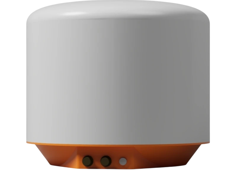
QL-RockGuard 3DR-1000 – Advanced MIMO + InSAR Rockfall & Slope Monitoring System
QL-SlopeGuard™ XR-300 is a high-precision, all-weather slope stability radar for real-time landslide and geohazard monitoring. Powered by advanced SAR and interferometry, it delivers 360° coverage and sub-millimeter deformation detection with ultra-low power consumption—ideal for long-term, unmanned monitoring of slopes, mines, dams, and critical infrastructure.
OVERVIEW
Description
Real-Time Rockfall & Slope Movement Detection Radar for Geohazard Early Warning
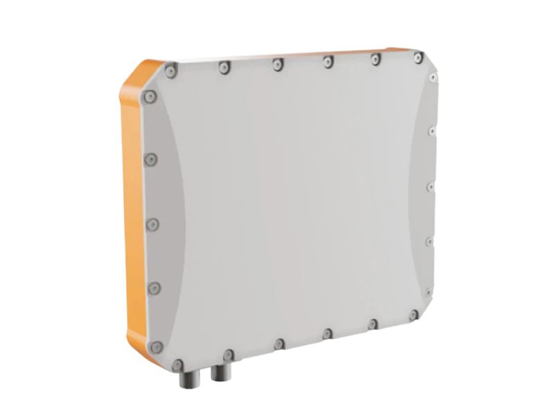
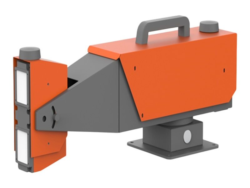
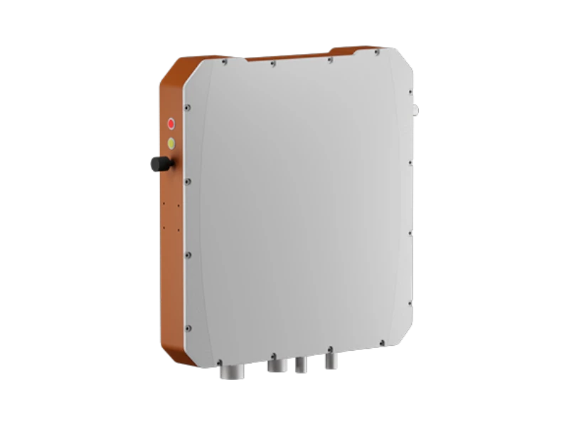
The QL-RockGuard™ 3DR-1000 is an advanced 3D rockfall and slope deformation monitoring radar built on high-resolution MIMO array technology and InSAR phase interferometry. Using electromagnetic waves as the sensing medium, it performs real-time, dynamic, non-contact detection of rockfalls, rolling stones, slope displacements, and fast-moving geohazard events across mountainous terrain, highways, rail corridors, and open-pit mines.
The integrated system includes a lightweight radar host, display/control terminal, multi-axis positioning mount, and power interface module. The display/control terminal connects wirelessly or via LAN to the radar host, allowing each operator workstation to control a single radar unit for precise three-dimensional monitoring across the full detection sector.
Compact, ultra-low-power, and field-deployable, the QL-RockGuard™ 3DR-1000 is engineered for mobile emergency response, long-term geotechnical monitoring, continuous early-warning operations, and rapid deployment in high-risk hazard zones—without requiring any reflectors or physical installation on the slope.
Why Choose QL-RockGuard™ 3DR-1000
Engineered for Industry-Leading Accuracy
-
Built on next-generation MIMO + InSAR radar architecture to capture rockfall motion, slope deformation, and hazardous movement in real time.
-
Delivers precise geohazard detection suitable for critical infrastructure and high-risk environments.
Non-Contact, Ultra-High-Sensitivity Monitoring
-
Detects micro-movements, early rockfall initiations, and fast-moving debris without any on-slope sensors or physical installations.
-
Ensures zero disturbance to the monitored area.
Reliable All-Weather, 24/7 Operation
-
Performs consistently in rain, fog, snow, dust, and total darkness.
-
Enables uninterrupted hazard surveillance under all environmental conditions.
Instant Deployment With Zero Structural Attachments
-
Requires no reflectors, no targets, and no mechanical anchors.
-
Fully stand-off operation from a safe distance improves deployment speed and operator safety.
Long-Range Performance up to 1000 Meters
-
Designed for highways, mountainous corridors, open-pit mine benches, cliff faces, and remote slopes.
-
Ideal for both short-range and extended monitoring zones.
Integrated Edge Computing
-
All data processing is handled on-board, eliminating the need for external computers or cloud dependency.
-
Provides real-time analytics, alarms, and event visualization directly from the unit.
Maintenance-Free, Solid-State Design
-
Zero moving parts ensure maximum reliability and superior long-term performance.
-
Perfect for permanent structural health monitoring (SHM) and automated early-warning systems.
Lightweight, Portable & Low Power
-
Weighs under 5 kg with <30 W power consumption.
-
Suitable for rapid emergency deployment, tripod or mast installation, remote sites, and solar-powered operation.
High Performance With Minimal Effort
-
Offers exceptional detection accuracy, multi-target tracking, and 3D visualization with minimal configuration.
-
Reduces installation time and overall project cost, making it ideal for large-scale monitoring programs.
Features
Key Features
1. Advanced MIMO + InSAR Radar Architecture
-
Utilizes advanced active microwave sensing for uninterrupted operation in rain, snow, fog, dust, or complete darkness.
-
Combines solid-state MIMO array technology with interferometric SAR for highly accurate detection and tracking of rockfalls, slope movements, and fast-moving debris.
2. Wide-Area 3D Coverage
-
Provides 90° × 30° scanning coverage with no moving parts, ensuring high reliability and minimal maintenance.
-
Supports importing 3D terrain models to overlay rockfall paths, real-time displacement vectors, and hazard zones directly on topographic basemaps.
3. High-Precision Tracking Performance
-
Detects targets as small as 0.1 m², with high-accuracy positioning, velocity measurement, and angular resolution.
-
Tracks 50+ moving objects simultaneously with rapid update rates ideal for dynamic, high-risk environments.
4. Mobile & Rapid Deployment
-
Lightweight < 5 kg integrated design enables fast installation by a single operator.
-
Includes a 2D turntable for quick azimuth and elevation adjustment during field deployment.
-
Suitable for mobile emergency monitoring, disaster response, and long-term fixed installations.
5. Ultra-Low Power, On-Site or Remote Operation
-
Low power consumption (≤30 W) supports off-grid or solar-powered operation.
-
Offers both local LAN connectivity and cloud-based remote monitoring options.
6. Intelligent Alarm & Multi-Device Integration
-
Automatically generates a real-time monitoring list including distance, direction, speed, and movement trajectory.
-
Configurable alarm zones eliminate false alarms outside the defined area of interest.
-
Multi-device linkage allows integration with optical/IR cameras to automatically focus on detected hazards.
7. Rugged, All-Weather Field Design
-
IP65 environmental protection ensures reliable operation in harsh outdoor environments.
-
Wide temperature range operation (–40°C to +55°C) supports deployment in extreme climates.
-
Built with waterproof and shock-resistant construction for demanding field conditions.
8. Intuitive Web-Based Control & Visualization
-
Browser-based interface (B/S architecture) enables deployment on a local PC or cloud server.
-
Offers simple configuration, customizable thresholds, and automatic audible/visual alarms.
-
Provides real-time 3D visualization, playback tools, and detailed event reporting.
9. Versatile Applications
-
Ideal for rockfall and landslide monitoring along highways, railways, tunnels, and open-pit mines.
-
Suitable for temporary emergency deployment during rescue or disaster response.
-
Supports scientific research, slope stability assessment, and long-term geohazard monitoring.
SPECIFICATIONS
Technical Specifications
Radar Performance
-
Monitoring Range: 20–1000 m
-
Coverage Angle: 90° (horizontal) × 30° (vertical)
-
Angular Resolution: ≤ 2°
-
Distance Resolution: ≤ 5 m
-
Velocity Resolution: ≤ 0.1 m/s
-
Angle Measurement Accuracy: ≤ 1°
-
Distance Measurement Accuracy: ≤ 3 m
-
Velocity Measurement Accuracy: ≤ 0.1 m/s
-
Minimum Detectable Target Size: ≥ 0.1 m²
-
Minimum Detectable Speed: ≤ 0.5 m/s
-
Maximum Detectable Speed: ≥ 30 m/s
-
Maximum Trackable Targets: ≥ 50
-
Data Update Rate: ≥ 2 Hz
System Architecture
-
Radar Technology: Solid-state MIMO + InSAR
-
Antenna Type: Electronically scanned, no moving parts
-
Mounting Platform: Integrated 2D turntable for azimuth/elevation adjustment
-
Data Display: Real-time 3D visualization with terrain model overlay
-
Alarm System: Multi-level thresholds with audible/visual warnings
-
Device Integration: Auto-linking to optoelectronic cameras for hazard zones
Hardware & Power
-
Radar Host Weight: ≤ 5 kg
-
Power Consumption: ≤ 30 W
-
Power Supply Options: 220 VAC or 24 VDC
-
Communication Interface: Wired LAN
Environmental Performance
-
Ingress Protection: IP65
-
Operating Temperature: –40°C to +55°C
-
Storage Temperature: –40°C to +65°C
-
Durability: Waterproof, dustproof, vibration-resistant construction
Software & Control
-
Architecture: B/S (Browser/Server)
-
Deployment: Local workstation or cloud server
-
Interface: Intuitive configuration dashboard
-
Alarm Zone Settings: User-defined shield areas to minimize false alerts
-
Target List Generation: Automatic calculation of distance, direction, velocity, and trajectory
Typical Applications
-
Rockfall and slope failure monitoring
-
Highways, railways, tunnels, and open-pit mining operations
-
Emergency hazard response and rapid deployment
-
Long-term geotechnical and geohazard monitoring
-
Research, engineering, and structural safety studies
APPLICATIONS
Applications
Highways & Transportation Corridors
-
Continuous monitoring of rockfalls and landslide-prone slopes along highways, mountain roads, and critical transport routes.
-
Real-time alerts to prevent vehicle accidents and support rapid response.
Railway Infrastructure
-
Detection of rockfalls, debris flow, and slope instability along rail corridors.
-
Supports early-warning protocols to protect trains and personnel.
Open-Pit Mines & Quarries
-
Monitoring of bench stability, pit walls, and haul roads.
-
Identifies fast-moving debris and hazardous rockfall trajectories for operational safety.
Tunnels, Bridges & Critical Infrastructure
-
Slope and portal monitoring around tunnel entrances and elevated structures.
-
Detects deformation or movement that may pose structural risks.
Disaster Response & Emergency Deployment
-
Rapid-deploy radar for post-disaster rockfall, landslide, or collapse zones.
-
Supports emergency teams by providing real-time hazard detection in dangerous environments.
Long-Term Geohazard & Slope Stability Monitoring
-
Ideal for long-term continuous observation of high-risk slopes, reservoirs, dams, and geotechnical sites.
-
Enables proactive mitigation and early warning for communities and assets.
Scientific Research & Engineering Studies
-
Supports geotechnical, civil engineering, and natural hazard research.
-
Provides accurate displacement tracking and real-time event data for analysis and modeling.
WHAT'S INCLUDED
What’s Included
Radar Hardware Package
-
MIMO + InSAR Radar Unit (lightweight, integrated design)
-
2D Adjustable Turntable for azimuth and elevation alignment
-
Weatherproof Mounting Bracket for rapid field deployment
-
Protective Carrying Case for transport and storage
Power & Connectivity
-
AC Power Adapter (220 VAC)
-
24 VDC Power Cable for alternative power sources
-
LAN Communication Cable
-
Surge Protection Module for field and outdoor environments
Software & Monitoring Tools
-
Browser/Server (B/S) Control Software
-
Real-Time Monitoring Dashboard
-
3D Terrain Visualization Module
-
Alarm Configuration & Event Logging Tools
-
Multi-Device Integration Interface (for linking cameras/optics)
Documentation
-
User Manual & Quick Start Guide
-
Installation & Alignment Guide
-
Safety Instructions
-
Software Configuration Manual
Support & Services
-
Remote Technical Support
-
Online Diagnostics & Troubleshooting
-
Firmware Updates
-
12-Month Standard Warranty (extended warranty available upon request)